
Rio2 Files NI 43-101 Technical Report for the Kalzas Tungsten Project, Yukon, Canada
VANCOUVER, British Columbia, July 14, 2026 (GLOBE NEWSWIRE) -- Rio2 Limited (“Rio2” or the “Company”) (TSXV: RIO; OTCQX: RIOFF; BVL: RIO) announces that the Company has filed on SEDAR+ an independent NI 43-101 Technical Report (the “Report”) supporting historical data, geology and potential of the Kalzas Tungsten Project located in Yukon, Canada.
The Report is entitled “Technical Report for the Kalzas Tungsten Project, Yukon, Canada” (the “Technical Report”). The report was independently prepared by Tatiana Alva Jimenez, M.Sc., P.Geo., of RUMI Geoscience Consulting on behalf of the Company in accordance with National Instrument 43-101- Standards of Disclosure for Mineral Projects (“NI 43-101”), dated July 10, 2026, with an effective date of June 19, 2026.
The Technical Report is available on the Company’s website at www.rio2.com and on SEDAR+ at www.sedarplus.ca.
About the Kalzas Tungsten Project
The Kalzas Tungsten Project (the “Kalzas Project”) consists of eight quartz mineral claims totalling approximately 155 hectares, situated within the Selkirk First Nation Settlement Land Block SFN-R-16A. The claims are active and verified as in good standing.
The Kalzas Project is located on the Kalzas Plateau in central Yukon Territory, Canada, south of the Stewart River, approximately 70 km southeast of Mayo and 290 km north of Whitehorse. The property is accessible from Whitehorse to Mayo, via the Klondike Highway to Stewart Crossing, then north along the Silver Trail Highway (Yukon Highway 11), followed by a 30-minute flight from Mayo to the Project site. Alternatively, the Project can be accessed directly by helicopter from Whitehorse.
The property is underlain by a geologically coherent porphyry-style vein-stockwork and sheeted-vein wolframite system hosted within the metasedimentary rocks of the Yusezyu Formation, Hyland Group. The system is spatially associated with a buried mid-Cretaceous pluton interpreted as part of the Tombstone Intrusive Suite. A K/Ar age of 90.0 ± 1.4. Ma (Lynch, 1985a) from altered biotite supports this interpretation. According to previous studies, tungsten mineralization consists predominantly of wolframite, with up to approximately 10% occurring as scheelite within quartz veins and a stockwork system.
The Kalzas Project occurs within the Selwyn Tungsten Belt, one of Canada’s most established tungsten metallogenic provinces, which hosts several significant tungsten deposits. Tungsten is classified as a critical mineral by Canada and many other countries, driven by its strategic importance in defence, aerospace, electronics, and energy transition applications.
History of the Kalzas Project
The Kalzas Property was discovered and staked in 1978 by prospector J.D. Randolph. Union Carbide Corporation optioned the property in 1980 and conducted the first systematic exploration programs between 1981 and 1983 and relinquished its option in 1984 following a significant downturn in the tungsten market (Dawson, 2006). The property was acquired by Copper Ridge Exploration Inc. in 2001, which conducted exploration programs between 2001 and 2005. In 2007, Prospector Resources Corp. entered into an option agreement to acquire the Kalzas property from Copper Ridge Exploration Inc. and conducted a diamond drilling program in 2008 and commissioned a Technical Report in 2016. Prospector Resources Corp. subsequently changed its name to Rio2 Limited, with trading of Rio2 common shares commencing on the TSX Venture Exchange under the symbol “RIO” on April 28, 2017. The Kalzas claim is currently registered as 100% owned by Rio2 Limited.
The claims are subject to the following royalties and encumbrances:
- A 2% Net Smelter Return (NSR) royalty payable to David Randolph and J.D. Randolph, as established under the 2005 NSR agreement between Copper Ridge Exploration Inc. and the Randolphs. Rio2 Limited has the right to acquire one-half (1%) of this royalty at any time for a pre-negotiated amount of CA$500,000.
- A 2% Net Profits Royalty (NPR) currently held by Golden Predator Mining Corp., a subsidiary of Victoria Gold Corp., as successor to Redtail Metals Corp. Rio2 Limited has the right to acquire one-half (1%) of this royalty at any time for a pre-negotiated amount of CA$500,000.
Exploration History
The Kalzas Property was discovered and staked in 1978 by prospector J.D. Randolph. Systematic exploration commenced in 1980 when Union Carbide Corporation optioned the property, conducting geological mapping, geochemical sampling, trenching, airborne geophysics, and diamond drilling between 1981 and 1983. Union Carbide relinquished the option in 1984 following a downturn in the tungsten market.
Surface geochemical programs conducted by Union Carbide (1981) and Copper Ridge (2001–2002) delineated a contiguous tungsten-in-soil and talus-fines anomaly exceeding 1,000 ppm W, measuring approximately 1,500 m in a northeasterly direction by 300 to 900 m in width. Trench sampling highlights include 1.04% WO₃ _over 150 m (Union Carbide, Line L43N) and up to 3.165% WO₃ _over 0.4 m (Copper Ridge, Upper Levels trench).
Copper Ridge Exploration Inc. acquired the property in 2001 and conducted resampling, geological mapping, and a five-hole diamond drilling program totalling 397.4 m in 2005. Prospector Resources Corp. entered into an option agreement in 2007 and completed a four-hole diamond drilling program totalling 505.5 m in 2008. Prospector Resources Corp. was subsequently renamed Rio2 Limited in 2017.
A total of 11 diamond drill holes have been completed at the property across three campaigns, totalling approximately 1,570.29 m. No exploration activity has been documented at the property since fall 2008. The 2016 Technical Report prepared by Doherty for Prospector Resources Corp. reported the details of the Prospector Resources 2008 drilling campaign.
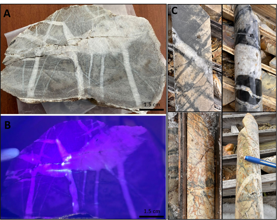
Examples of the rock lithology, alteration and mineralization observed during the site visit on May 27, 2026, are shown in Figure 1.
Source: Rio2 Limited
Figure 1: Float rock sample collected at the Kalzas Project. A. Hand Sample showing quartzite with quartz and quartz-tourmaline veins. B: Same sample under UV illumination showing scheelite fluorescence concentrated along fracture and quartz intersection. C: Examples of lithology, alteration, and mineralization (K-08-11 drill core). Quartzite with quartz stockwork veins with tourmalinization and sericitization (dark patches) along selvage and fracture.
Historical Geochemical Highlights
Historical soil and talus fines geochemical samples have defined a well-developed tungsten geochemical anomaly at the property.
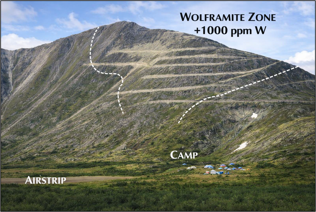
Surface geochemical programs conducted by Union Carbide (1981-1984) and resampled by Copper Ridge (2001-2002) delineated a contiguous tungsten-in-soil and talus-fines anomaly exceeding 1,000 ppm W, measuring approximately 1,500 m in a northeasterly direction by 300-900 m in width (Figure 2).
Trench sampling highlights included 1.04% WO3 over 150 m (Union Carbide) and, from the Copper Ridge Upper Levels trench, up to 3.165% WO3 over 0.4 m and 2.552% WO3 over 2 m. Higher grade zones appear to be structurally controlled, trending west-northwest and preferentially developed within quartzite-dominated host rock intervals.
The full extent of the anomaly remains open in several directions and is not fully tested at depth.
Source: C. Roots, digitally coloured using AI
Figure 2: Southeast view of the tungsten zone on West Kalzas, Twin Mountain
Historical Drilling Highlights
A total of 11 diamond drill holes have been completed at the Property across three campaigns totalling 1,570.29 m. Reliable drill hole data comes from the Copper Ridge (2005) and Prospector Resources (2008) drilling campaigns. Highlights include drill hole KZ05-01, which contains a 1.9 m interval grading 1.122% WO3 within a broader 48 m intersection averaging 0.153% WO3, and drill hole KZ05-05, which contains two narrow intervals (0.5 m each) grading 1.220% and 1.390% WO3 within a broader 24.4 m intersection averaging 0.304% WO3. Prospector Resources (2008) drilling program highlights include drill hole K-08-09, which returned 0.287% WO3 over 15 m. This interval is contained within the broader 101.36 m intersection averaging 0.224% WO3, representing the most significant higher-grade sub-interval identified in the 2008 program.
Table 1: 2005 Drill Hole Assay Highlights, Copper Ridge, Kalzas Project
| Hole | From (m) | To (m) | Interval (m) | WO3(%) |
| KZ05-01 | 11 | 59 | 48 | 0.153 |
| includes | 29.6 | 41 | 11.4 | 0.304 |
| and | 29.6 | 38 | 8.4 | 0.393 |
| and | 29.6 | 32 | 2.4 | 0.688 |
| and | 36.1 | 38 | 1.9 | 1.122 |
| KZ05-02 | 33 | 62 | 29 | 0.13 |
| includes | 50 | 52.1 | 2.1 | 0.391 |
| KZ05-03 | 3 | 11 | 8 | 0.246 |
| includes | 28 | 30 | 2 | 0.24 |
| 49.2 | 53.8 | 4.6 | 0.26 | |
| KZ05-04 | 16 | 21.5 | 5.5 | 0.221 |
| 64.9 | 84.7 | 19.8 | 0.145 | |
| includes | 64.9 | 68.5 | 3.6 | 0.231 |
| KZ05-05 | 0 | 24.4 | 24.4 | 0.304 |
| includes | 7 | 14 | 7 | 0.419 |
| and | 9 | 17.4 | 8.4 | 0.533 |
| and | 9.8 | 10.3 | 0.5 | 1.22 |
| and | 16.9 | 17.4 | 0.5 | 1.39 |
| 58.4 | 60 | 1.6 | 0.38 | |
| 84 | 85 | 1 | 0.72 | |
Table 2: 2008 Drill Hole Assay Highlights, Prospector Resources, Kalzas Project
| Hole | From(m) | To (m) | Interval (m) | WO3(%) |
| K-08-08 | 11.07 | 29.06 | 17.99 | 0.172 |
| K-08-08 | 35 | 60.5 | 25.5 | 0.153 |
| K-08-09 | 34 | 135.36 | 101.36 | 0.224 |
| including | 52 | 82.5 | 30.5 | 0.234 |
| including | 56.5 | 71.5 | 15 | 0.287 |
| K-08-10 | 0 | 29 | 29 | 0.066 |
| K-08-10 | 65 | 92 | 27 | 0.101 |
| K-08-11 | 0 | 42.5 | 42.5 | 0.158 |
| K-08-11 | 124.5 | 150.5 | 26 | 0.069 |
Technical Report Conclusion
The Kalzas Project hosts a geologically coherent, well-characterized porphyry-style wolframite vein-stockwork system with meaningful bulk-tonnage exploration potential. The geological model is consistent with known tungsten deposits within the Selwyn Tungsten Belt and is well-supported by historical surface geochemistry, trench sampling, alteration mapping, aeromagnetic data, and three diamond drill programs conducted between 1983 and 2008.
Historical drilling has tested only a small fraction of the mineralized system — a zone approximately 300 m by 200 m on the northwest flank of Kalzas Mountain — within a broader 1,500 m by 800 m mineralized envelope defined by surface geochemistry. The geological model predicts that mineralization extends to depth beyond the approximately 180 m tested by historical drilling, and along strike beyond the currently drilled area, particularly on the western flank of Kalzas Mountain. These represent the primary targets for a future drill program.
Advancement of exploration at the Kalzas Project is subject to the resolution of three conditions in sequence: completion of the Selkirk First Nation ("SFN")-mandated site remediation program, acceptance of the Class 1 exploration permit, and negotiation of a formal exploration agreement with the SFN. Rio2 is committed to advancing these requirements in a collaborative and respectful manner with the Selkirk First Nation.
Proposed Exploration Program
A two-phase exploration program is planned to commence shortly at the Kalzas Project, with a mandatory pre-requisite phase that must be completed before field activities can commence.
The pre-requisite phase includes completion of the SFN-mandated site reclamation program, scheduled to begin in July 2026 and budgeted at CAD60,875 (plus applicable taxes). Advancement is also contingent on acceptance of the Class 1 exploration permit filed on April 13, 2026, and execution of a formal exploration access agreement with the Selkirk First Nation. Yukon-based geological consultants, Archer Cathro, have been engaged by Rio2 to manage the site reclamation work and the subsequent two-phase exploration program during the 2026 field season.
Phase 1 consists of data compilation, geological mapping, and surface geochemical sampling, budgeted at CAD66,830 (plus applicable taxes). The program is designed to establish the foundation for effective drill targeting and includes consolidation of all historical exploration data into a validated georeferenced database, 1:5,000-scale geological mapping and prospecting by a crew of three geologists, collection of approximately 50 rock samples for multi-element ICP-MS analysis at ALS Laboratories, and re-sampling of talus and rock material around the margins of the established tungsten geochemical anomaly. The Phase 1 field program is planned for late July or August 2026, subject to permit acceptance and SFN engagement, and will be conducted from a fly camp accessed by helicopter from Mayo.
Phase 2 consists of a 1,500–2,000 m diamond drilling program to be designed following interpretation of Phase 1 results, estimated at CA$1,305,000 to $2,050,000 (plus applicable taxes). Drill targets will focus on depth extensions of wolframite mineralization below the approximately 180 m vertical limit of historical drilling, along-strike continuity to the northeast and southwest guided by the ~1,500 m surface geochemical anomaly, the untested western flank of Kalzas Mountain, and twinning of selected holes from the 2005 and 2008 programs to validate historical assay data.
The total recommended expenditure across all three phases is estimated at approximately CA$1,400,000 to $2,200,000, exclusive of applicable taxes.
Figure 3 shows the recommended target areas for Phase 1 and 2 explorations, focused on the western flank and untested strike/depth extensions.
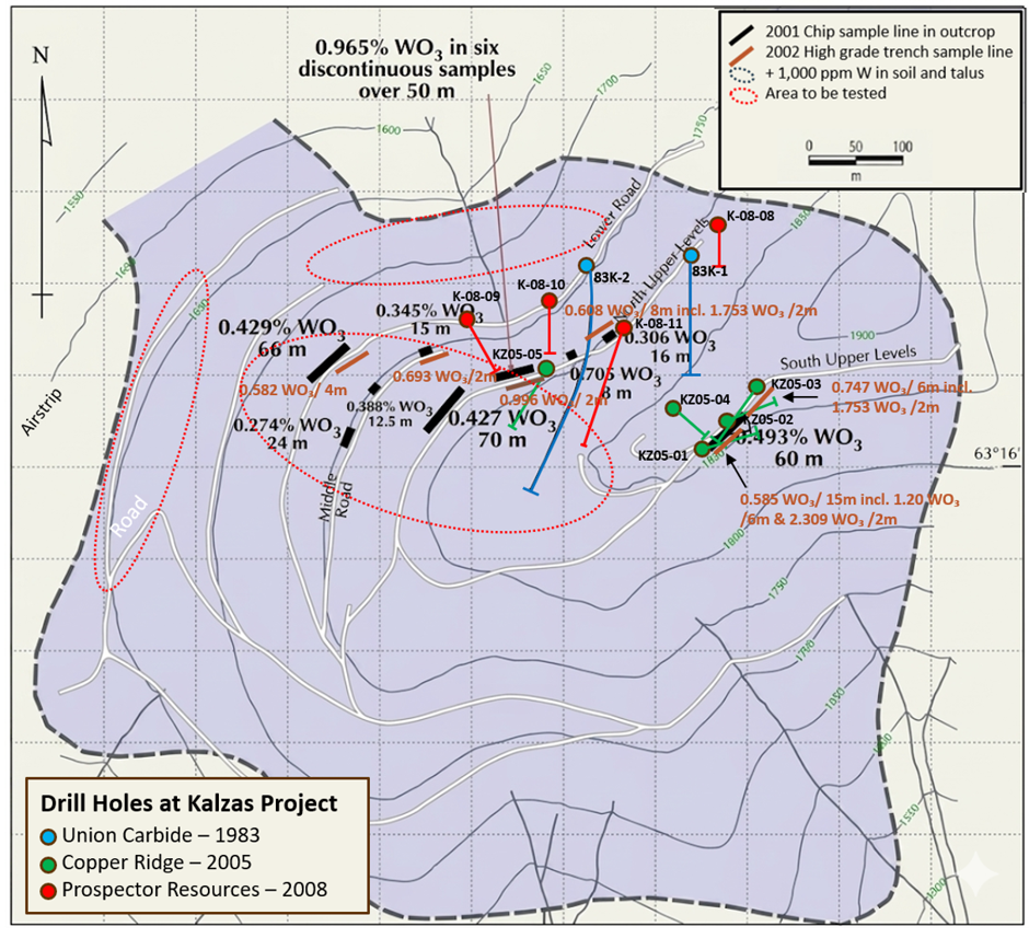
Figure 3: Kalzas Project drill hole locations, surface sampling highlights, and recommended priority drill target area (red dashed outline). Background shading denotes> 1,000 ppm W soil and talus anomalies.
Qualified Person
The scientific and technical content of this press release has been reviewed, approved and verified by Enrique Garay, MSc P.Geo/FAIG, SVP Geology, Rio2 Limited, who is a QP under NI 43-101.
The Technical Report was prepared by Tatiana Alva Jimenez, M.Sc., P.Geo., Principal Geologist of RUMI Geoscience Consulting, who is an independent Qualified Person as defined by NI 43-101. Ms. Alva Jimenez has reviewed and approved the scientific and technical information contained in this news release, which fairly and accurately reflects the information contained in the Technical Report.
ABOUT RIO2 LIMITED
Rio2 is a diversified precious metals and copper producer focused on building and operating mines with a management team that has proven technical skills as well as a successful capital markets track record. The Company is currently producing gold at its Fenix Gold heap leach mine in Chile and copper/gold/silver at its recently acquired Condestable underground mine in Peru. Rio2 and its wholly owned subsidiaries, Fenix Gold Limitada and Compañía Minera Condestable S.A., are companies that operate with the highest environmental standards and responsibility with the firm conviction that it is possible to develop mining projects that respect the three pillars (Social, Environment, Economics) of responsible development. As related companies, we reaffirm our commitment to apply environmental standards beyond those mandated by regulators, seeking to protect and preserve the environment in the territories where we operate.
Forward-Looking Statements
This press release contains forward-looking statements and forward-looking information (collectively “forward-looking information”) within the meaning of applicable securities laws relating to Rio2’s Kalzas Project and other aspects of Rio2’s future operations and plans. In addition, without limiting the generality of the foregoing, this press release contains forward-looking information pertaining to the following: the phased exploration program proposed to be conducted on the Kalzas Project including the work to be completed in advance of the commencement of the exploration program; the expected cost of the exploration program; and other matters ancillary or incidental to the foregoing.
All statements included herein, other than statements of historical fact, may be forward-looking information and such information involves various risks and uncertainties. Forward-looking information is often, but not always, identified by the use of words such as “seek”, “anticipate”, “plan”, “continue”, “estimate”, “expect”, “may”, “will”, “project”, “predict”, “potential”, “targeting”, “intend”, “could”, “might”, “should”, “believe” and similar expressions. The forward-looking information is based on certain key expectations and assumptions made by Rio2’s management, including but not limited to: the successful negotiation of a formal exploration agreement with SFN; receipt of regulatory and other third party approvals; the availability and cost of labor and services; and the legislative and regulatory environment of Yukon.
Rio2 believes the expectations reflected in these forward-looking statements are reasonable, but no assurance can be given that these expectations will prove to be correct and such forward-looking statements in this press release should not be unduly relied upon. A description of assumptions used to develop such forward-looking information and a description of risk factors that may cause actual results to differ materially from forward-looking information can be found in Rio2's most recent annual information form on the SEDAR+ website at www.sedarplus.ca. These risks and uncertainties include, but are not limited to: risks and uncertainties relating to market conditions, risks associated with our operations, risks that required third party and regulatory approvals are not obtained on satisfactory terms or at all, and management’s ability to anticipate and manage the factors and risks referred to herein.
Forward-looking statements included in this press release are made as of the date of this press release and such information should not be relied upon as representing its views as of any date subsequent to the date of this press release. Rio2 has attempted to identify important factors that could cause actual results, performance or achievements to vary from those current expectations or estimates expressed or implied by the forward-looking information. However, there may be other factors that cause results, performance or achievements not to be as expected or estimated and that could cause actual results, performance or achievements to differ materially from current expectations. Rio2 disclaims any intention or obligation to update or revise any forward-looking statements, whether as a result of new information, future events or otherwise, except as expressly required by applicable securities legislation.
To learn more about Rio2 Limited, please visit: www.rio2.com or Rio2's SEDAR+ profile at www.sedarplus.ca.
ON BEHALF OF THE BOARD OF RIO2 LIMITED
Alex Black
Executive Chairman
Email: alex.black@rio2.com
Tel: +51 99279 4655
Kathryn Johnson
Executive Vice President, CFO & Corporate Secretary
Email: kathryn.johnson@rio2.com
Tel: +1 604 762 4720
Photos accompanying this announcement are available at:
https://www.globenewswire.com/NewsRoom/AttachmentNg/7c870f3a-c0b0-4d8b-b12c-8116ccd3bdfe
https://www.globenewswire.com/NewsRoom/AttachmentNg/bff1d0fa-9105-4287-8ee4-127a45b596f3
https://www.globenewswire.com/NewsRoom/AttachmentNg/1a9d3ac3-84ed-4c02-a6eb-ff9a412310f4


Figure 1
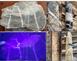
Float rock sample collected at the Kalzas Project. A. Hand Sample showing quartzite with quartz and quartz-tourmaline veins. B: Same sample under UV illumination showing scheelite fluorescence concentrated along fracture and quartz intersection. C: Examples of lithology, alteration, and mineralization (K-08-11 drill core). Quartzite with quartz stockwork veins with tourmalinization and sericitization (dark patches) along selvage and fracture.
Figure 2
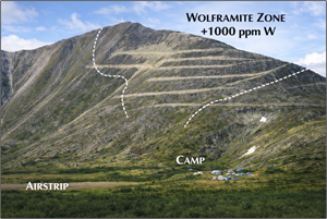
Southeast view of the tungsten zone on West Kalzas, Twin Mountain
Figure 3
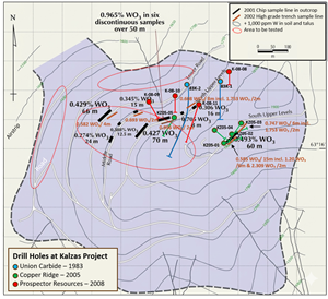
Kalzas Project drill hole locations, surface sampling highlights, and recommended priority drill target area (red dashed outline). Background shading denotes> 1,000 ppm W soil and talus anomalies.
Legal Disclaimer:
EIN Presswire provides this news content "as is" without warranty of any kind. We do not accept any responsibility or liability for the accuracy, content, images, videos, licenses, completeness, legality, or reliability of the information contained in this article. If you have any complaints or copyright issues related to this article, kindly contact the author above.
